Spain’s 2026 wildfire season in review: provisional figures and lessons for prevention
By the SilvIA Earth team · Published · Updated
Provisional data as of 3 November 2026. Spain's autonomous communities are still closing fire perimeters, so these figures will continue to be revised.
With the high-risk summer campaign now over, the provisional 2026 figures point to a season of high incidence and very large burned areas, above the averages of the past decade and calling for rigorous planning of management resources.
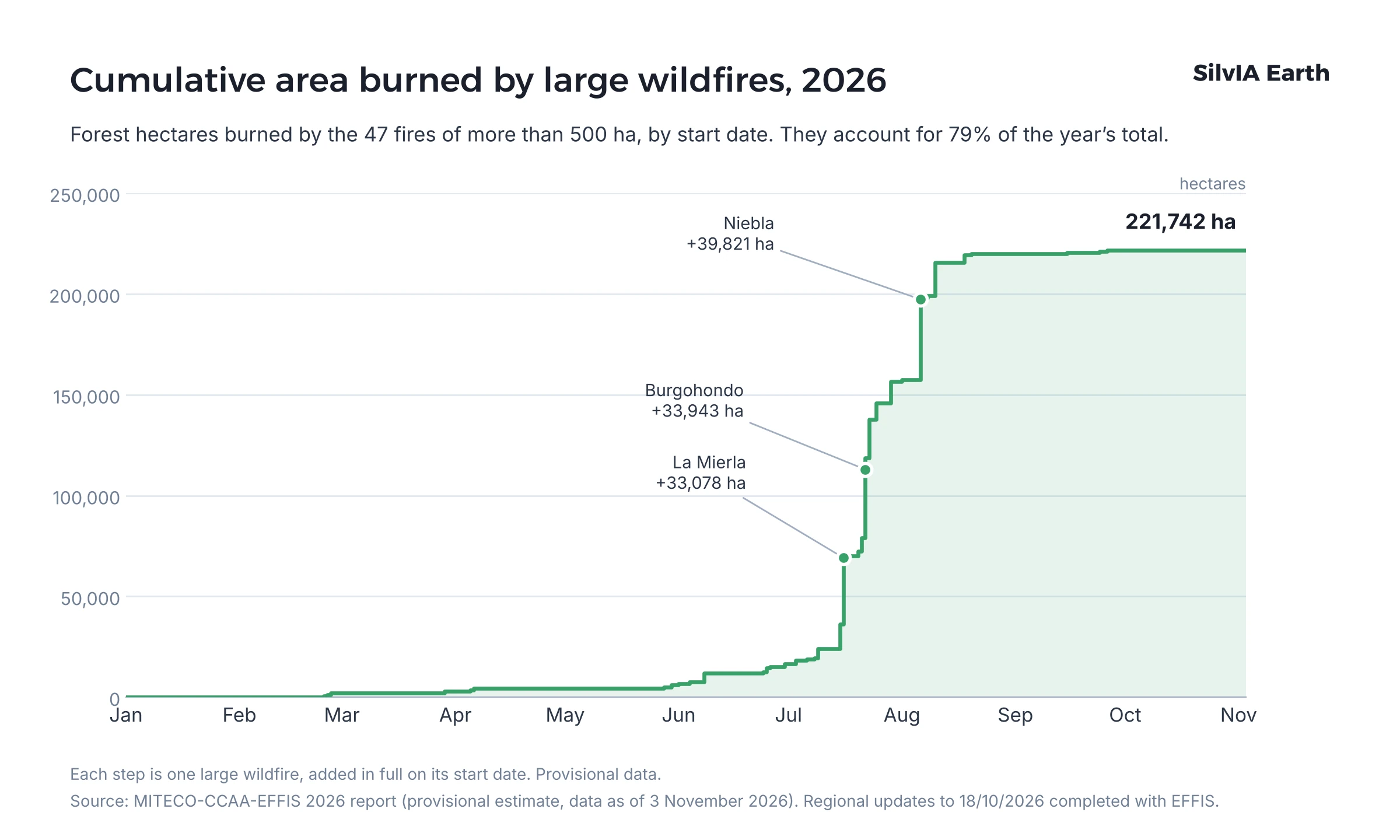
According to the provisional estimate by Spain's Ministry for the Ecological Transition (MITECO), the burned forest area stands at 280,048 ha, 122% above the 2016–2025 average. There have been 47 large wildfires, that is, fires of more than 500 ha, 64% above that same average.
These figures are not final. Some regions kept the high-danger period in force until late October. The data below will be adjusted as the autonomous communities close their perimeters.
How the burned area grew through the year
The 2026 season arrived earlier than usual. On 5 July, MITECO recorded 50,751 ha; by 17 August, 254,730 ha. In roughly six weeks some 204,000 ha burned, around 73% of the whole year's total. In 2025, by contrast, the main wave came in August.

By autonomous community
Castile and León is the region with the largest burned area (60,318 ha), closely followed by Andalusia (58,844 ha). Castile and León also had more large wildfires: 10 against 6. Together the two account for 43% of the area burned in Spain, and the top five regions reach 78%.
| Autonomous community | Forest area (ha) |
|---|---|
| Castile and León | 60,318 |
| Andalusia | 58,844 |
| Castilla-La Mancha | 41,807 |
| Aragon | 35,930 |
| Community of Madrid | 22,471 |
| Cantabria | 16,206 |
| Extremadura | 15,176 |
| Valencian Community | 10,675 |
| Asturias | 6,702 |
| Galicia | 5,319 |
| Catalonia | 3,829 |
| Region of Murcia | 1,220 |
| Navarre | 1,109 |
| Basque Country | 270 |
| La Rioja | 116 |
| Balearic Islands | 36 |
| Canary Islands | 21 |
| Ceuta | 0.1 |
| Melilla | 0 |
| Total Spain | 280,048 |

In several regions, a single fire accounts for most of the total. The Niebla fire represents two thirds of the area burned in Andalusia; the San Martín de Valdeiglesias fire, 81% of the area burned in the Community of Madrid; and the La Mierla fire, 79% of that in Castilla-La Mancha.
What kind of land burned
Of the 280,048 ha affected, 156,498 ha were wooded land (55.9%), 94,021 ha shrubland and open woodland (33.6%) and 29,529 ha grassland (10.5%). The wooded area burned is more than three times the 2016–2025 average. It is also the first time in the decade that wooded area has exceeded non-wooded area. MITECO already pointed this out in mid-August (MITECO, 17/08/2026), and the provisional November data confirm it.
Note: Galicia and Aragon report non-wooded land without separating shrubland from pasture, so all of it is counted as shrubland and open woodland. The actual grassland area is therefore somewhat larger than shown.
The large wildfires
The 47 large wildfires by size:
- 500–1,000 ha: 21 fires
- 1,000–2,500 ha: 13 fires
- 2,500–5,000 ha: 5 fires
- Over 5,000 ha: 8 fires
The five largest fires of the year:
- Niebla (Huelva, Andalusia): 39,821 ha
- Burgohondo (Ávila, Castile and León): 33,943 ha
- La Mierla (Guadalajara, Castilla-La Mancha): 33,078 ha
- San Martín de Valdeiglesias (Madrid, Community of Madrid): 18,177 ha
- Las Peñas de Riglos (Huesca, Aragon): 16,522 ha
Together, these five account for more than half of all the forest area burned during the year.
Several forced thousands of people to evacuate or shelter in place. In the Community of Madrid alone, 21,000 people were evacuated or confined (El Mundo, 28/07/2026). On 24 July, the Spanish Government declared an emergency of national interest in the Community of Madrid and the province of Ávila.
Spain in the European context
According to the European Forest Fire Information System (EFFIS), as of 4 November 2026 Spain has accumulated 301,651 hectares burned, 44% of the total area burned in the European Union and the largest share of any Member State.
The EFFIS figure is higher than that of MITECO, whose latest update, with data to 3 November, puts the burned forest area at 280,048 hectares. This is not an error: they measure different things. EFFIS maps from satellite everything that burns above a certain size, including farmland, whereas MITECO adds up forest area from the reports submitted by the autonomous communities. That is why the two figures need not match, not even once the season is closed.
A forester's reading of the season
What burned this summer started growing months earlier. The 2025–2026 winter was very wet: average rainfall in mainland Spain reached 323.2 mm, 171% of normal, making it the eighth wettest winter since 1961 (AEMET, 12/03/2026). That water fuelled abundant growth of grass and shrubs. Then came the hottest summer since at least 1869, with a mean of 24.5 °C in mainland Spain, 2.4 °C above normal, and the third driest since 1961 (AEMET, 21/09/2026). The heat turned that biomass into available fuel.
That is why the large wildfires came so early. By 22 July, 22 large wildfires of more than 500 hectares had already been recorded, against a ten-year average of 9 by that date (MITECO, update to 22/07/2026). Many of these fires escaped initial attack and required the maximum deployment of resources. Fine, already-cured grass spread the fire quickly, while dense shrubland and very dry trees made spot fires easier.
The second lesson is concentration. As shown above, five fires account for more than half of the burned area, and the 47 large wildfires for almost 80%. In four regions, a single fire explains between 56% and 81% of the region's entire total (MITECO-CCAA-EFFIS, provisional estimate as of 03/11/2026). The Niebla fire (Huelva) alone burned nearly 40,000 forest hectares and destroyed around 80% of the Pata del Caballo natural site, according to an estimate by the Escacena del Campo Town Council. With this pattern, spreading prevention evenly across the territory is not effective. Large wildfires grow or are stopped in specific places: fuel continuities, exposed slopes, wind corridors. That is where preventive action changes the outcome.
The season was also a reminder that risk is not measured in hectares alone. The deadliest fire of the year, at Los Gallardos (Almería), in which 13 people died, is not among the largest: at around 4,500 forest hectares, it was the ninth largest of the year. In the wildland-urban interface, protection strips around homes and housing estates and the upkeep of individual plots matter as much as work in the forest.
Why the 2027 season is decided in winter
What determines the size of a large wildfire in July is, to a great extent, the fuel accumulated in the forest, and that fuel is managed during the low-risk months. Preventive silviculture, strategic clearing, firebreak maintenance and prescribed burning have a limited window and a finite budget. The operational question is where to do them first to reduce risk as much as possible.
How much fuel there will be in 2027 will depend on this autumn's and this winter's rainfall. In September, AEMET gave a 60% to 70% probability of a warmer-than-normal autumn (AEMET, 21/09/2026). Planning now makes it possible to adjust priorities as that becomes clear.
Where SilvIA Earth fits in
SilvIA Earth combines satellite data with weather and terrain variables to rank areas by wildfire risk before ignition occurs. Based on that analysis, we prepare recommended action plans. Our goal is to bring predictive analytics to those who manage and protect the land, so they can anticipate what is going to happen on their ground and make decisions based on reliable information.
Sources and methodology
Figures for Spain come from the MITECO-CCAA-EFFIS 2026 report (provisional estimate, data as of 3 November 2026), which combines the autonomous communities' updates to 18 October with subsequent EFFIS data. Weather data are from AEMET (Spain's State Meteorological Agency) and European figures from EFFIS (Copernicus), consulted on 4 November 2026. EFFIS and the national statistics use different methodologies, so their figures may not match. All 2026 figures are provisional. Other sources are linked in the text.